
Tropical Cyclones #7 - MPI and Drag

There’s a theory from Kerry Emanuel called maximum potential intensity (MPI). It describes the maximum possible wind speed for a tropical cyclone and how that maximum changes as temperatures increase.
We’ll get into the details in due course. One key ingredient is the drag coefficient —a measure of how much momentum is transferred from the wind to the ocean.
As winds build, how much are they slowed by the air–sea interface?
One of my first questions on seeing the MPI formula was: How do we know what this coefficient is, especially under very high wind speeds?
Here’s a paper that measured it - Bottom-Up Determination of Air-Sea Momentum Exchange Under a Major Tropical Cyclone.
Conventional methods of determining the air-sea momentum transfer are from the atmospheric side of the interface and are based on measurements of wind profiles near the ocean surface or of wind turbulence. These methods, however, cannot work reliably for the extreme high-wind conditions of a major tropical cyclone, because wind measurements near the ocean interface are inevitably contaminated from intense breaking-wave activities and sea spray.
The authors took a different approach—a “bottom-up” determination from ocean currents—which is challenging:
However, this type of “bottom-up” determination imposes the almost impossible requirements of deploying instruments in the ocean directly under the highly unpredictable path of a major tropical cyclone and then having the instruments survive the enormous forces generated by the cyclone.
On 15 September 2004, the center of Hurricane Ivan (at category 4 strength) passed directly over six current and wave/tide gauge moorings on the outer continental shelf in the northeastern Gulf of Mexico. The instrumentation survived and measured nearly full ocean current velocity profiles directly under the cyclone. The resulting data set allows direct“bottom-up” determination of the air-sea momentum exchange under extreme wind conditions.
Here’s the graph of their results:
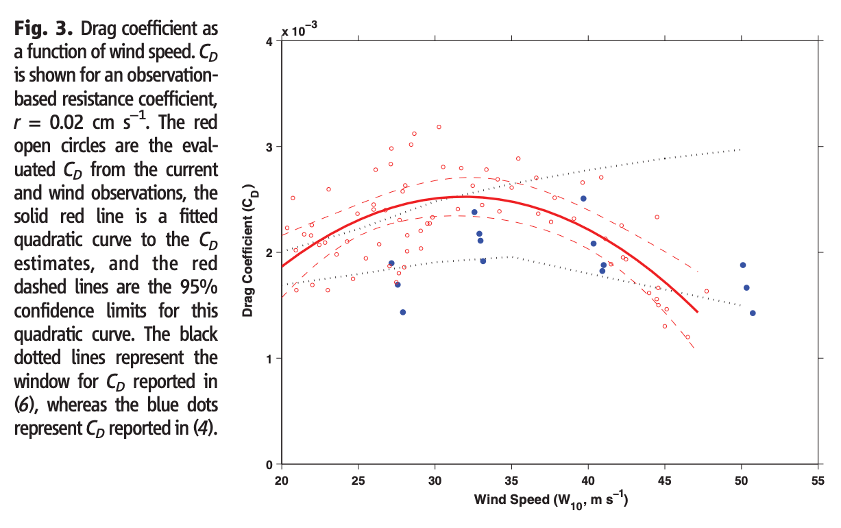
From their analysis:
Thus, the behavior of the drag coefficient (CD) can easily be estimated for a range of strong winds. Despite the fact that the drag coefficient is evaluated differently here, estimates of CD determined “bottom-up” reasonably replicate the values determined “top-down” in recent studies (3–7). Results from our research show that CD peaks at a wind speed near 32 m/s and then steadily decreases as the wind speed continues to rise.
For reference, 32 m/s is about 115 km/hr or 71 mph.
Because the drag coefficient appears to peak around this value and then decline, MPI calculations that assume constant values will underestimate the maximum possible wind speed.
Another paper looking into the details of the air-ocean interface from this era was Air–sea exchange in hurricanes: Synthesis of observations from the coupled boundary layer air–sea transfer experiment. For people interested in the details of how important stuff gets measured this is worth taking a look at - you can find it for free via Google Scholar.
The drag coefficients (CD) estimated from this work suggest a leveling off with wind speed near 22-23 m/s, which is a considerably lower threshold than the 33 m/s value of Powell et al. (2003) and Donelan et al. (2004).
As is often the case, different teams get different results, especially in challenging environments like tropical cyclones.
Reference
Bottom-Up Determination of Air-Sea Momentum Exchange Under a Major Tropical Cyclone, Ewa Jarosz et al, Science (2007)
Air–sea exchange in hurricanes: Synthesis of observations from the coupled boundary layer air–sea transfer experiment, PG Black et al, American Meteorological Society (2007)